Cart Track
Indoor and outdoor cart positioning, movement tracking, GPS integration, and automated control.
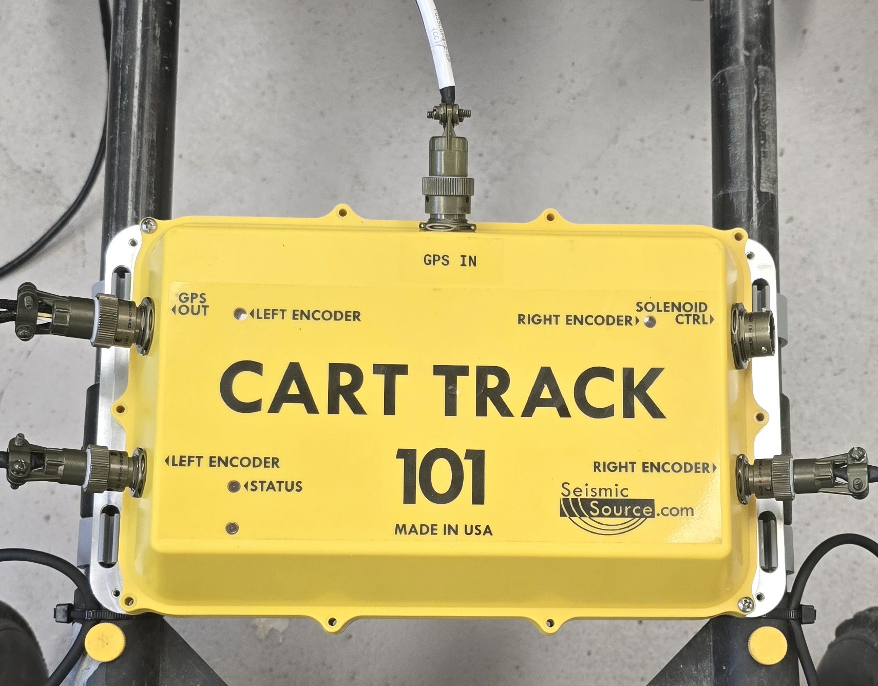
Cart Track
Overview
Cart Track is a cart-mounted positioning and control system designed to measure and record cart movement in indoor and outdoor applications. It combines wheel-encoder measurements, external GPS input, real-time position mapping, calibration tools, correction-service support, and NMEA output in one system.
For indoor work where satellite positioning is unavailable, Cart Track uses wheel encoders to calculate distance and position. The operator establishes a known starting point, and Cart Track generates simulated NMEA position data as the cart moves.
For outdoor operation, GPS Passthrough forwards live NMEA data from the connected GPS receiver. Compatible correction data may be supplied through Wi-Fi, Bluetooth, or an NTRIP correction service to support improved outdoor positioning.
Cart Track includes a browser-based interface for viewing position, encoder values, distance traveled, the movement trail, GNSS status, and system settings. The interface is accessed by connecting to the Cart Track Wi-Fi network and opening the given IP address.
On supported SeisMike systems, Cart Track can also control an automatic mechanical tapping source for concrete and asphalt evaluation.
Notice: Cart is not included with purchase of Cart Track.
For a complete field-ready setup, Cart Track can be paired with our Cart System or with any compatible cart system.
Features
- Uses wheel encoders to measure cart movement indoors
- Calculates distance and position when GPS reception is unavailable
- Generates simulated NMEA position data from a known starting point
- Allows the starting latitude and longitude to be entered manually
- Can load the current starting position from a connected GPS receiver
- Supports live NMEA data from a connected external GPS receiver
- GPS Passthrough forwards external GPS NMEA directly to connected equipment
- Displays fix status, satellite information, position, and altitude
- Displays additional receiver information with compatible Seismic Source GNSS units
- Adjustable serial baud rate, data bits, parity, and stop-bit settings
- Displays the cart’s calculated position while moving
- Shows the traveled path as a real-time movement trail
- Displays encoder counts and total distance traveled
- Supports map clearing and session resetting
- Recorded movement data can be downloaded as a CSV file
- Rollup calibration determines distance per encoder count
- Wheelbase calibration improves turning and position calculations
- Displays distance per count and distance per wheel revolution
- Allows known calibration values to be entered manually
- Calibration values can be saved for use after the system restarts
- Local Wi-Fi interface for system setup and operation
- Connects to a hotspot or router while keeping the Cart Track interface available
- Supports compatible RTCM correction data through Wi-Fi or Bluetooth
- Built-in NTRIP client for supported GPS correction services
- Compatible with Seismic Source AccuNav and other compatible NTRIP services
- Available for supported Seismic Source SeisMike systems
- Controls the automatic mechanical tapping source
- Manual, distance-interval, and time-interval firing modes
- Adjustable solenoid pulse width
- Configurable TTL synchronization output for recording equipment
- Adjustable synchronization timing and pre-start delay
- Browser-based configuration interface
- Current operating and connection status display
- Downloadable tracking data
- Firmware update capability
- Compatible with phones, tablets, and computers with Wi-Fi and a web browser
Power
| Spec | Value |
|---|---|
| Operating voltage | 5–24 V DC |
Connectivity
| Spec | Value |
|---|---|
| Wi-Fi | SoftAP + client (STA) |
| Bluetooth | BLE for RTCM correction input |
| Web interface | Browser configuration and status |
| Firmware update | OTA over Wi-Fi |
Wheel Odometry
| Spec | Value |
|---|---|
| Encoders | Dual quadrature |
| Resolution | 360 quadrature cycles per revolution |
| Outputs | Distance, heading, NMEA, and simulated NMEA odometry |
GNSS
| Spec | Value |
|---|---|
| External GNSS | RS-232, bidirectional |
| Default serial | 19200, 8N1, configurable |
| GNSS link | RTCM/UBX input, NMEA output |
| GPS Out | NMEA at 19200 baud, odometry or GNSS passthrough |
| PPS | 1 Hz output and GNSS PPS input |
| Corrections | NTRIP over Wi-Fi, Bluetooth, and TCP passthrough on port 50050 |
Control I/O
| Spec | Value |
|---|---|
| Solenoid output | Dry contact, solid-state relay |
| Load type | DC only, polarized; observe polarity |
| Rating | 3–32 V DC, up to 5 A |
| Notes | Freewheel diode fitted; reverse connection is not supported |
| Sync output | 3.3 V TTL fire-event output |
| Fire control | Manual button or web control, distance interval, and time interval |
Benefits
- Encoder positioning supports indoor operation where satellite reception is unavailable, while GPS Passthrough supports live outdoor positioning.
- Cart Track provides position and distance information as the cart moves, helping operators document movement throughout a survey or evaluation area.
- The cart-mounted design allows Cart Track to be integrated with compatible customer carts and specialized Seismic Source systems.
- Rollup and wheelbase calibration allow the system to account for the installed wheel and cart geometry.
- The real-time map provides immediate visual feedback, while CSV downloads allow recorded position data to be reviewed or processed after collection.
- Compatible GNSS receivers and optional NTRIP corrections can improve outdoor positioning for supported applications.
- On supported SeisMike carts, automatic distance- or time-based tapping helps maintain consistent source operation during concrete and asphalt evaluation.
- Operators can access Cart Track settings through a standard web browser using the system’s local Wi-Fi network.
Related Applications
Cart Track supports indoor and outdoor applications requiring cart position, movement, and distance data.
- Use wheel encoders to generate position data in warehouses, buildings, plants, tunnels, and other areas with limited GPS reception.
- Use GPS Passthrough with a connected receiver for real-time outdoor positioning and NMEA output.
- Integrate with supported SeisMike systems for position tracking and automatic mechanical tapping.
- Record cart movement and position during evaluation, testing, mapping, and data-collection work.
- Receive compatible RTCM correction data through Wi-Fi, Bluetooth, or an NTRIP correction service.